Together with the Hessian State Agency for Nature Conservation, Environment and Geology HLNUG and the working group Engineering Geology of the TU Darmstadt, our group is working on the project “Environment 4.0” Subproject 2: Use of digital terrain models and Copernicus data.
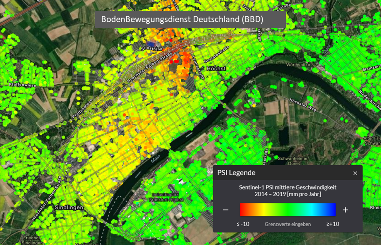
Due to falling groundwater levels and low groundwater recharge during dry periods, large-scale subsidence can occur, which can cause damage to buildings, for example. Radar interferometry, a remote sensing technique, makes it possible to observe ground motions in the mm range. The Ground Motion Service Germany BBD has collected results of Persistent Scatterer Interferometry (PSI), a special form of radar interferometry, and made them available in a WebGIS application (see header image). Satellite data from Sentinel-1 of the Copernicus mission of the European Space Agency (ESA) were used for this purpose.
It is noticeable that information is only available for built-up areas. This is a limitation of the PSI method, which relies on rectangular structures in the environment. These rectangular structures occur much more often in man-made structures, such as buildings, bridges and power poles, than in meadows, fields and forests.
In the Environment 4.0 project, we are researching ways to fuse PSI data with data created from laser scan overflights. Digital surface models (DSMs) and digital terrain models (DTMs) are generated from laser scan data. These overflights take place in Hesse approximately every 3 years. If two DTMs of different points in time are subtracted from each other, difference maps are generated that show the ground motion during this period. Another possibility is to use another radar interferometry method that is less dependent on rectangular structures, such as the Small Baseline Subset (SBAS) method.
The goal of the project is to provide an areal representation and validation of ground motion patterns in Hesse and their geological interpretation. This engineering geological state survey contributes to the defense against geohazards and is becoming increasingly important, especially in view of the changing climate behavior.
The project is funded by the Hessian Minister for Digital Strategy and Development.